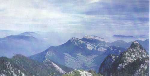
| Looking north from near the top of Grand Som, the highest peak in the
Chartreuse Hills. The grassy valley contains the soft shales of the core of the
Corbel fold, with the bands of limestone at the head of this valley running over the crest
of the fold. The Subalpine chains stretch off to the right and distance. The
prominent wooded ridge leading into the distance from left of view is the crest of one of
the Jura folds. This divergence between the Jura and Subalps off to the north
defines the margins of the hazy low ground - the Annecy basin. |