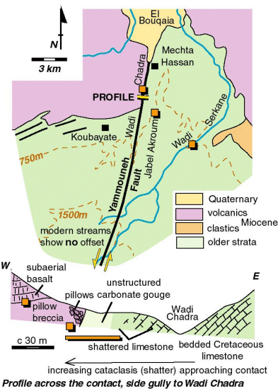
The Yammouneh Fault runs north, out of the high ground of Mount Lebanon
and into low ground largely containing lavas - the Homs basalt.
The southern edge of the basalt outcrop appears to be offset by the
Yammouneh Fault - a map pattern that is classically used to infer the amount
of displacement on the fault since the basalt erupted. But the outcrops
tell a different story. The basalt appears to have erupted against the
fault - not be offset by it. There is no sign of faulting of the basalt
in Wadi Chadra. Furthermore, the young streams show no offset. There is
evidence for the fault however and pre-basalt landforms are offset. So
the conclusion to be drawn is that te Yammouneh fault moved, offset the
landscape (essentially the anticline of Mount Lebanon) and then this landscape
was part filled in by basalt. The basalts are dated as older than 5 million
years old. So this northern part of the fault looks to have been inactive,
at least as a major strike-slip fault over the past 5 Myr.
| Dead Sea Transform front page | Structural locations map |